|
|
Clan Magner |
|
| Contact Us | Home | Site Map | Family Trees | History | Search | Queries |


![]()
|
|
A HISTORY OF THE MAGNER’S AND CASTLE MAGNER Denis O’Donoghue Dedicated to the memory of the late Eddie O’Donoghue of Castlemagner, Ireland
ACKNOWLEDGEMENT To Very Rev. Canon Lawrence O’Donoghue P.P. a kindly ambassador for his native Castle Magner. His guidance and encouragement enabled this account to be written. PREAMBLE This is an informal note on the history of the Castle of the Magners. The relevant historical records are mainly included in the Hayes Collection Index in the National Library. They are very scant indeed. Like many other smaller castles the history of Castle Magner survives largely in the folklore of the local community. For all its apparent shortcomings, the local tradition on Castle Magner stands up surprisingly well and to date as such records have been found bear out the local version of its history. It is not now possible to show who exactly it was that built the various buildings on the castle site or with authority to date their construction. Probably the most informed local commentator on Castle Magner was the late EDDIE O’DONOGHUE of Castlemagner who died in 1980 aged 69 years. His interest was kindled as a young boy on his father’s farm at Knockardsharrive where the ever-present castle in the trees across the Cathragh glen beckoned an heroic challenge for youthful exploration. Amid the pressures of family farming, running the Castle Bar, parish activities and commanding the local FCA Kanturk Battalion, in adult life his abiding interest in the castle deepened into serious study. Astute and resourceful on his subject, his extensive knowledge of the history of the district and the families in the parish brought many calls for his help with historical and family studies. His repayment was an occasional nugget of rare information regarding the history of the castle which survived in the family memory or professional lore of his visitor and which could be added to the mosaic of his collection. Through the old people, some of whom were only a few generations away from the generation who knew the Magners in their castle, he collected an amount of original detail. The many noted antiquarians, who visited this old and historic parish, found in him an able guide and a well-informed proponent. In the process he tested and tempered against these substantial experts the construct which he was assembling for the history of the place. Sadly he died before very much of his findings were put down and his work has remained largely unrecorded. The account which follows is collated from private notes and letters and from conversations with members of his family, particularly with his wife Mary B. and his brother Lawrence. Where possible, it is fully tested against such historical documentation as can be located. It attempts to salvage as much as possible of his unique store of folklore and historically supported information. Albeit belatedly, it is his contribution to uncovering the story of Castle Magner. He would want to remind the reader that only where satisfactory physical or documentary evidence is available can any historical comment be accepted as correct. Denis O’Donoghue Sligo September, 1990
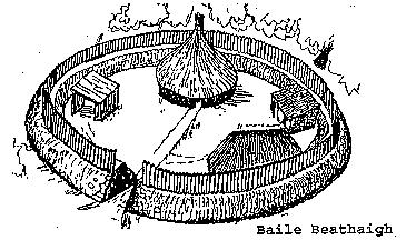
CASTLEMAGNER Castlemagner parish is at the sough eastern end of Duhallow and includes the northeast quarter of Kanturk town. A thousand years of careful farming has enriched the naturally fertile soil and in all its 7880 acres there is no waste land. The troubled history of the nation has ebbed and flowed over its green fields since time immemorial. It was an old and settled place when the Magnels from Pembrokeshire made their way along the Blackwater valley and sank their roots deep into Castlemagner soil to shape the life of the parish for more than 450 years. The old Gaelic name for the part of Castlemagner lying between the Owenbeg and Cathragh rivers was Monamandragh "The Bog (or meadow) of the Water Parsnip" – a weed still in the river there. The people of the district lived in family groups of protected Raths called "Baile Beathaigh."
Their domestic animals grazed in the woods and scrub land and the open spaces were cleared and fenced for cultivation, pasture land and meadow. The Brehon Laws regulated their complex society while their Warrior Class of chiefs and their followers engaged in constant power struggles and conflicts. Four fifths of the people were ordinary non-combatants and led peaceful and Christian lives under the monastic and paruchial Church, sharing in the wide learning culture and way of life of the wider Gaelic community. Great public events and more local affairs like weddings and patterns were occasions for frequent gatherings and celebrations. A deep-rooted sense of identity and place is reflected in the names they gave to the places, rivers and hills about them; names which are still widely in use today. The Tuatha of Monamandragh was in the Mor Tuatha of Duhallow and part of the ancient Principality of Fera Maighe Fere. This Principality extended from Sliabh Luachra to Fermoy and from the Boggeragh and Nagle mountains to the Ballyhoura Hills. The O’Kief sept at Glanworth and later at Dromagh were its hereditary chiefs. It was in the Kingdom of Desmond under the lordship of Cormac "Draggletail" McCarthy when the fierce struggle between the O’Briens and the McCarthys for the kingship of Munster was at its height. The entire country between Cork and Limerick was in disorder and the conflict continued under Cormac’s sons and grandsons until the invading Normans arrived in AD1169 to deprive both sides of most of the disputed kingdom. The Norman invasion came into Cork in November of that year and continued piecemeal over the next 20-years. The invaders lacked resources for a war of total conquest and acquired much of their territory by making alliances with the warring Gaelic chiefs and getting tracts of land as payment. In the disputed lands they built castles and towns which they garrisoned and held against all comers with ruthless efficiency. The chiefs and their followers were shattered and dispersed westwards to the mountain country of Cork and Kerry and across the Lee and Bandon rivers to the South.
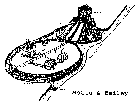
Robert Fitz Stephen, one of the most brutal leaders of the invasion, over-ran Monamandragh and the eastern districts of Dahallow during AD 1175-78. By AD 1185 the Normal takeover of North and East Cork was almost complete. Dermod "Cill Baghan" McCarthy, the last king of Desmond was killed that year and his successor Donal "na Curra", the first McCarthy Mor, was established in Killarney. The chieftain in Dormagh was Cornelius O’Kief. Raymond le Gros de Carew, nephew of Robert Fitz Stephen, held or laid claim to most of county Cork and systematic Norman colonization had begun. Philip de Barry, grand-nephew and heir to Robert Fitz Stephen, had taken over the Lordship of Ui Liathain and other lands in County Cork. His first centre was Barry’s Court near Carrigtohill (built AD 1200) where he had 3 cantreds. He later moved to Castlelyons (build AD 1204) where he also held 3 cantreds. In eastern Duhallow and Muskerie Donegan he held 3 cantreds which included the seized Tuatha of Monamandragh. These lands were given the name Orreria Barrie (or Orrery) for their relocation along the eastern edge of Gaelic Dunhallow. De Barry brought a settler group under William Magunel with him from Manorbier in February AD 1183. Magnel was to be the leader of Barry’s forward Settlement in Orrery. His kindred Settlement took over about 1500 acres in and around Monamandragh. Barry’s other Feudal Settlement in Cahir Ultan near Middletown had been initiated by Ralph Fitz Stephen around AD 1179 under Raymund Magunel or Magnel, as the name was also given. About 600 acres of Monamandragh, including a well-developed Gaelic centre at Munemanarrach (Shrubbery of the Sheepfold), were assigned for William Magnel’s Manor Village and Manor Farm. Later the rest of Monamandragh was granted to the Knights Templars. This warlike order of lay monks was drawn exclusively from high-ranking Norman families. The Templars constructed a Station or Preceptory on a sight overlooking the Owenbeg river where Subalter House now is. A Manor Farm and Village was developed at Marybrook. The Farm was a 600-acre demesne taking in the town lands of Subalter Knockranuss and Lackaleigh. The King’s Castles at Loghort and at Liscarrol were also built at this time. Magnel’s initial base was a Motte & Bailey raised earlier on the right bank of the Cathragh River and 150 yards west of the present Ardoyne Bridge. At the ease end, the 30ft high Motte mound was 30ft in diameter and supported a wooden tower about 25ft in height. At the west end, the egg-shaped Bailey was 120ft long and 60ft across at its widest point. The whole construction was enclosed by an elliptical moat formed by the river to the south and a ditch fed from the river on the other sides.
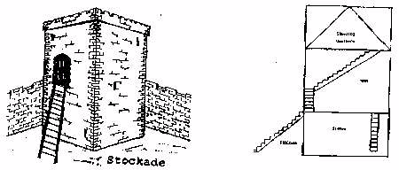
Around AD 1200 a stronger position was developed by David Fitz William Barry on the site of the Gaelic village at the top of the hill. A Norman tour or Stockade was built on the rocky promontory over the river. This stone-built tower was about 20ft x 20ft external at the base with walls 5ft thick and rising to around 35ft. It was protected by a heavy stone wall or embankment. The Manor Farm of about 600 acres comprised the present town lands of Castlemagner/Lisduggan, Coolavalleen and Knockardsharrive. It was already fenced in and set to tillage and pasture by the previous Gaelic occupiers who were more competent farmers than the invaders and were retained as the main workforce on a share-crop basis. Otherwise the local people were left as before but were compelled to conform to the Norman system of Land Tenure and Usage and were subject to the legal process of Leet and Baron courts. A hundred years later with the formation of civil parishes, the Gaelic community at Munemanarrach was again associated with the sister community in Subalter under Norman parish clergy and a Norman Bishop of Cloyne.
Around this time, a water mill was constructed on the river at the Motte & Bailey. The Motte was leveled and a 20ft x 20ft stone mill house was set on it. The mill had a 5ft vertical internal stream wheel with a yew pit & wallower coupling to a small buhrstone quern brought in from a quarry near Paris. The moat was altered to make a sluice-gated leat and trailrace. A Drying Kiln was built in the Bailey, near to the mill. This all-wood mill was in use until the Plantation Rebellion of AD 1598. Pieces of rock brought from Wales as ballast, survived as curios or memento’s on the site until recently. Unusual-shaped pieces of Subalter rock were also on the site until recent times. The Magners developed their Kindred Settlement around the functioning Gaelic centre with its cadre of Gaelic tenants and laborers under Norman-Welsh management. By AD 1250 it was an established Norman town and was called (Magnel) Castleton and Magnelstown for its Magnel founder. The family were known as the Magnels of Orrery and were emerging as persons of standing in the Norman community of County Cork. The Gaelic chiefs in the Kingdom of Desmond vigorously opposed the Norman occupation from the start. In AD 1182 Robert Fitz Stephen’s son Ralph, Robert de Barry father of Philip, and their leader Milo de Cogan, were all killed near Lismore. Dona na Curra McCarthy Mor burned Limerick City in AD 1196 and with the unlikely help of the O’Briens he compelled the Normans to evacuate Cork City. In AD 1261 Donal’s grandson Fineen Mac Donal Gott destroyed an elite Norman army at Roughty Glen near Kilgarvan. Lord John Fitz Thomas of Desmond & Decies and Lord David Barry, powerful leaders of their time, were killed there with many of their followers. The next year at Callan Fineen’s brother Cormac destroyed the army of McWilliam Bourke and killed Lord Roche "The third best Knight in Ireland." These heavy defeats broke the Norman grip on Sough Kerry and on West and South West Cork and the Gaelic recovery pushed east as far as Kilbrittain, Blarney and Ballynomona. In the recovered lands, the Gaelic chiefs and their followers prospered and proliferated with numerous independent jurisdictions and castles marking the recovery of Gaelic power and influence. The Gaelic recovery continued into the early AD 1300s and Magnels Stockade in Magnelstown was lost or dismantled as the McDonagh McCarthys exploited David Fitz David Barry’s distraction with the Scottish wars. Behind the protective bulwark of Liscarrol, Subalter and Loghorn, the Magnels escaped the distress inflicted on their more powerful overloads. Their settlement developed rapidly to catch the stability and prosperity of the thirteenth century and the opportunities afforded by the monasteries and administrative centres rising up around them. Their emergence at the highest level in the affairs of the county was counter-balanced locally by the McDonagh McCarthys who created the lordship of Duhallow at Castle na Curra in AD 1242 with Barry, Cogans, Roches and other leading Norman families, the Magnels of Orrery appear in the then key roles of Curers and Legal Witnesses for State land transactions. The nomination of Philip Magnel as Bailsman for Henry de Ridlesford a ranking Norman of Royal lineage, gave recognition to his important public status. Philip’s later nomination in AD 1297 as a Joror for a Royal grant of land for a nunnery near Kinsale, confirmed his senior social standing. Locally the Magnels featured in legal matters with the Barrys and the Roches and with the landowning Bishops of Cloyne. The Magnels of East Cork, who frequently appear in records with them, seem to have been of the same stock. Their shipping interests in Waterford and in Dungarvan were contemporaneous with the continental trading activities of the Magnels of Magnelstown. The Magnels were also appointed Agents or Rent Collectors for the Gaelic Tenants of Crown lands in the civil barony of Orrery and Kilmore and the family held that appointment until Cromwellian times. Not all the Magnels were so well set-up. Thomas Magnel was paying a rent of 3d for a cottage in Cloyne. Gilbert Magnel was hanged in Clonmel for stealing from a church and others appear as petty criminals and as disturbers of the peace. The fourteenth century brought trials and tribulations as the McCarthys raided and raged through the colonist areas and generally "played the devil in Numster." Isolated by the increasing usage of English as the language of the Administration, by AD 1350 the Gaelic/French-speaking Magnels had passed the high point of their social and political achievements. There after, they emerged as farming gentry concerned with the land and with local affairs and closely involved with the Lords Barry Mor in protecting common interests. Towards the last quarter of AD 1300s, the reforming activities of Lionel Duke of Clarence and William of Windsor caused great alarm among the colonists and gave the Gaelic chieftains another opportunity to recover further territory from Norman control. To protect his march districts under the shadow of the King’s castle at Loghort, David Og Fitz David Barry fortified Kilmaclenin, Lisgriffin and Castlecor. At Magnelstown he build a Watch Tower to complete a defensive line from Loghort to Liscarrol and under the eye of his own strong castle at Buttevant. This type of works was strongly advocated by William of Windsor who provided a grant of L10 for fortifications such as Magnels Tower during AD 1375 – 6.
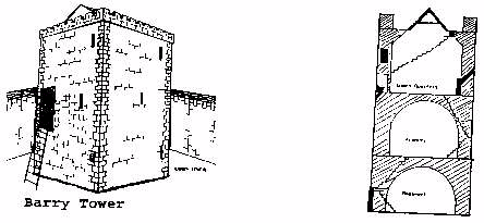
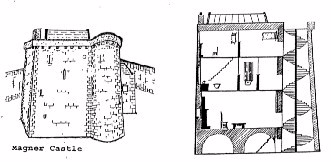
The new structure was located at the southwest corner of the existing Stockade which was converted to a granary. The Watch Tower was 24ft x 24ft external at the base with walls 5ft thick and rose to a height of 45ft. A retractable ladder rose to a door in the east wall, 13ft from the ground. A Watch Captain with about 10 of Lord Barry’s men were the guard. The watch fell to be maintained by the Magnels when government funds ran out, as they usually did. The McDonagh McCarthys continued to push the Gaelic recovery eastwards until the Magnels were in an isolated island of Orrery and completely surrounded by McCarthys’ Duhallow. Due to lack of money, the King’s castles at Liscarrol and at Loghort were allowed to run-down and the Templar Preceptory in Subalter also fell into decay. In AD 1307 that Order was suppressed by Henry III and the Preceptory and lands wee given to the rising Order of Knights Hospitaller of the Holy Sepulcre of Jerusalem. The Hospitallers, who ran a system of Recuperation Centres for Knights wounded in the Crusades, did not halt the decay of the Station and by AD 1350 it had reverted to the Bishop of Cloyne as beneficiary of unassigned Crown land within the diocese. The main tenants of the demesne in AD 1366 were the Magnels and the Barrys. The Magnels also tenanted Church land in Clonmeen and in Kilmaclenin. The incursions of Donal an Daimh McCarthy Mor and his son Teige Liath in AD 1460 brought most of the Barry Mor and other Norman lands west of Mallow under McCarthy Black Rent tribute. Donagh Og McDonagh McCarthy occupied and held the castles of Kilbolane, Castlecor, Loghort and Mallow. In the eye of the storm, the Watch Tower in Magnelstown was taken out of commission but the resilient Magnels continued in possession of the land. In AD 1467 the Lord Deputy Sir Thomas Fitzgerald Desmond pacified the area as far as Kanturk without drawing down serious fighting. In the subsequent settlement Donagh Og brought Castlecor from Lord Barry Nor and retained Kilbolane which he gave to his brother or nephew Teig McCarthy of Knocktemple. He also retained Loghort Castle which he proceeded to re-build to its present style and layout. On authority from or through Lord Barry Mor, the Barry Tower in Magnelstown was developed into a castle. Built on Barry land by Thomas Magnel, it was a type of better-class farm residence popular with the tenanting gentry of the time. It was also a token counter-balance to the impressive McCarthy presence at Loghort less than a mile distant. Magnel’s Castle was rubble-built with local limestone and had a small amount of cut stone for the windows and doorways. The unmatched cut stone was salvaged from the extensive Norman ruins at Subalter. The rough stone dressing and basic masonry work was carried out by local masons. Existing work, including the powerful enclosure walls and the surviving portions of David Og Barry’s well-built Watch Tower, were incorporated into the new buildings. A thrifty cost-cutting was a recurring characteristic of the Magnels. The walled enclosure was extended to the north and laid out 110ft NS x 12ft EW and the walls, 4’-6" thick, were raised to an internal height of 14ft. Circular stone stairs led to an interrupted open 2ft parapet with a corner turret over the SE approaches. A fortified gate house was built towards the SW corner. The Keystone of the gate-arch carried a small relief carving of St. Michael the Archangel. A private chapel was also built in the angle of the enclosure walls at the SW corner. A sile na Gig carved on a small slab was taken from the ruined seventh century church in the Church Field in Subalter and built into the wall of Magnel’s chapel. A water tank was set midway into the East enclosure wall with an ox or horse-worked winch for raising water from the river below the wall. The construction of the Castle followed a common pattern. The old keep was out to 30ft x 30 ft at the base and rebated internally to offset the external rake of the walls. The keep was also raised to accommodate a third floor with a protected alure and battlement and was generally fitted out as a family residence. A novel circular stair turret, 8ft in internal diameter, was built into the SE corner of the keep. This part of the building has survived and shows the corner of David Og Barry’s Tower and first-floor entrance with Magnel’s Stair Turret built into it. Barry’s well-chosen courses and cut stone cornering contrasts with Magnel’s rougher but strong rubble building. The wall of the Turret was 3ft thick and was 2’ 6" into the wall of the Keep. The self-supporting spiral stairs was braced and kerfed to the inner wall of the turret and rose to the roof through half-landings at each floor level. A handrail rising on the right stringer gave this sturdy oak stairs a light and graceful appearance. Off the landings the cut stone doorways were each of different design and were offset 10 degrees from each other for a Machicoller over the ground floor entrance to the Keep. The external door or main entrance was at ground level in the north wall of the turret, with four cut stone steps leading to it. The entrance gave directly to the turret stairs and to the basement of the Keep. The corona and battery of the turret were integrated with the alure and battlement of the keep to give a single-unit appearance to the finished building. The lightly-built compact structure rose to a height of about 56ft to give a strong and unusual Tower House which achieved the objective of impressing the countryside. In its sylvan setting the Castle was a pleasant residence of the period and was to be an enduring landmark in the locality.
The anglicizing legislation of AD 1465 enabled the Magnels to formally change their name to Magner. This was a Gaelic form of the name from the Gaelic custom of changing names ending with el. to a diminutive of familiar ending er. Magner was the local and popular version of the name from very early times and was the version used formally by all branches of the family from around AD 1480. The civil parish and the district was called "Castle Magner" as the family moved once again to the rank of minor gentry. David Magner also had the Castle of Kilmaclenin and James Magner got a lease of Castle Connelly from the Stapletons in AD 1483. Aside from the castle, Magnertown in AD 1500 had a Manor Church and burial ground – the present graveyard, the Manor Village to the north and west of the Church, a large Gaelic village across the river under Coolavalleen and corn mill on the river below Ardoyne hill. The hereditary cure of the parish Church was with the Sheen family who were connected with a church settlement in Kilavalling. The Sheehans were priests in Castle Magner and Kilbrin down to penal times. The area was traversed with a network of dirt tracts and improved roads leading to outside farms at Coolavalleen, Knockardsharrive and Subalter. A primary road led from the castle over the ford at Ardoyne and along the left bank of the Cathragh/Owenbeg River to Roskeen. It turned east along the left bank of the Blackwater to the busy pass-town of Mallow. This reasonably good stoneway was kept in repair to carry the year-round flow of farm produce from this productive hinterland. The stony ford crossing at Ardoyne was centered about 30 yards up-stream from the present Ardoyne bridge and spread over 30-40 yards along the right riverbank where the going was soft and wet over the rocky underlay. The primary road had developed from the rough access rout from Mallow to the original Motte & Bailey and still served the Cornmill until the second bridge was built in the AD 1880s. The route from the ford to the castle led more or less right of straight ahead by the brow of the hill over what is now a quarry to the original castle gates. Continues to Part 2:
|
Web site established: August 25, 1998. Site designed, hosted and owned by Ronald Magner Knowles. Problems with this site should be addressed to: webmaster Copyright 1990-2007: © RMK Research. All rights reserved. A link to this site would be appreciated, but NO photos, text or information may be copied without prior written permission. Any infringement will be subject to legal action. Disclaimer Site sponsored by: SMOGCHECK.COM™ and SmogTestOnly and TestOnlySmogCheck and OrangeCountySmogCheck.Biz and AnaheimSmog.Biz and CostaMesaSmog.Biz and SantaAnaSmog.Biz and WestminsterSmogCheck.Biz and OCSmogCheck.Biz and Garden Grove Smog Check and Mainstreet Smogcheck and SmogTest.Biz and Huntington Beach Smog Biz and Smog Check California and Smog Test California |